
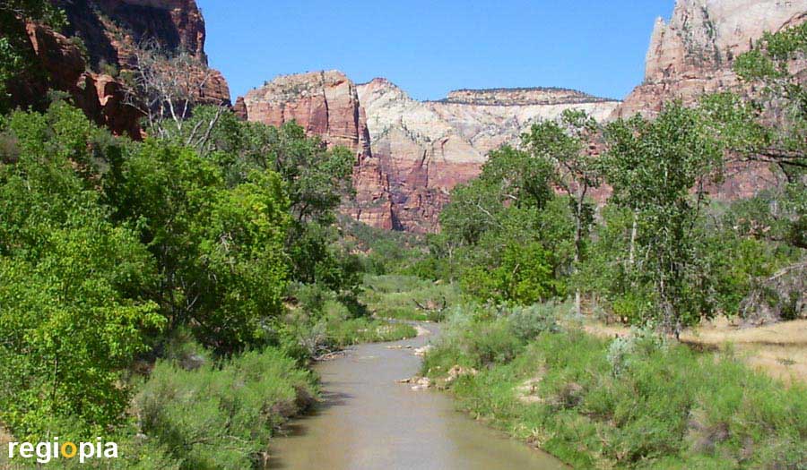
Zion National Park
The Zion National Park in Utah is about 250 km to the north-east of Las Vegas. The national park belongs geologically to the Colorado Plateau, which mainly consists of layers of sand and limestone. 17 million years ago, the former seabed was raised to 3,000 m and has since eroded into a rugged landscape. Zion National Park consists of two parts, the northern part is called the Kolob Canyon Section. This part is characterized by narrow gorges with huge red rock formations. Most of the sights are in the southern part, called the Zion Canyon Section. The Virgin River created the Zion Canyon and exposed huge rock formations that glow in different colors depending on the light.
The Mormons were the first settlers in the park and gave the valley the name "Zion". Zion is a mountain in Jerusalem and is considered to be the place of God. It was a place of calm and security for the Mormons, but they only used the park in summer. In 1918 the "Zion Canyon" was declared a national park. The valley of the Virgin River is around 1300 m high, the highest mountain in the southern part is the 2,380 m high "West Temple". The highest mountain in the northern part is the "Horse Ranch Mountain" with 2,664 m.
Main attractions of the park are the Emerald Pool, the Observation Point and The Narrows at the northern end of the Virgin River. The hiking routes can be found on the map that can be obtained from the Visitor Center or on the Zion National Park website (see link). If you leave the national park to the east (Clear Creek), you will pass petrified dunes. In the very south of the national park is the "Parunuweap Canyon" on the East Fork Virgin River. There is a prehistoric settlement of the Anasazi Indians, who also inhabited Pueblo settlements in Mesa Verde, Colorado.
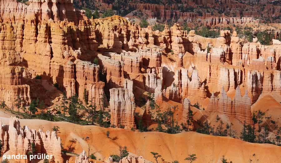
Bryce Canyon
From Zion National Park about 130 km to the north-east you get to Bryce Canyon. Weathering resulted in bizarre limestone pillars that offer a fairytale panorama. On the approximately 30 km long Paunsaugunt Plateau, most of the viewpoints are on the park road, which leads to Rainbow Point at 2,775 m. The splendid colors of the stone pillars are created by the binding agents iron and manganese oxide, which ensure different color gradients depending on the angle of incidence of the light. In the valleys, the red sand of the weathered limestone cliffs collects, on which some trees grow that add a few splashes of green color to Bryce Canyon National Park.
Anasazi Indians settled in Bryce Canyon and disappeared again in the 13th century. Spanish missionaries met Paiute Indians in 1776. The Mormon Ebenezer Bryce tried his hand at settling in the canyon named after him in 1874. Bryce eventually moved on to Mexico. Bryce Canyon was declared a national park in 1928. The most famous hiking trails are the 2.2 km long Navajo Loop Trail and the slightly longer Queen's Garden Trail. Both hiking routes lead through the most beautiful part of the national park, the "amphitheater". The Navajo Loop begins and ends at Sunset Point. The 2.9 km long Queen's Garden Trail starts at Sunrise Point and ends at Sunset Point. You can find maps and other hiking trails on the Bryce Canyon National Park website (see link). Bryce Canyon is one of the most beautiful national parks in the USA.
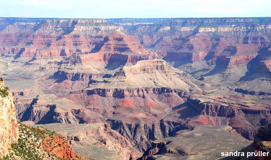
Grand Canyon
The 1,600 m deep Grand Canyon is 6-30 km wide and around 160 km long. The Grand Canyon is vast and one of the most famous natural wonders on earth. Standing on the edge of the precipice is overwhelming. For many visitors, the Grand Canyon is the highlight of a trip to the USA.
History of the Grand Canyon
Over 17 million years, the Colorado River cut into the Kaibab Plateau, which is around 2,500 m high, exposing the various layers of rock. The plateau is sloping, so the southern edge is about 400 m higher than the northern edge of the canyon.
Arriving from Las Vegas
From Las Vegas you can drive to the North Rim or South Rim. The north and south rims of the canyon are each 450 km from Las Vegas. The southern rim of the Grand Canyon is more touristy than the northern one. This is also due to the fact that you are facing the sun from the North Rim. There is also a road at the South Rim that runs parallel to the canyon from which you can go to many different viewpoints. If you only want to take a day trip from Las Vegas to the Grand Canyon, you can also go to the "Grand Canyon Skywalk" (see link) in Peach Springs, Arizona. This is only about 180 km from the gamblers metropolis.
http://grand-canyon-skywalk.business.site
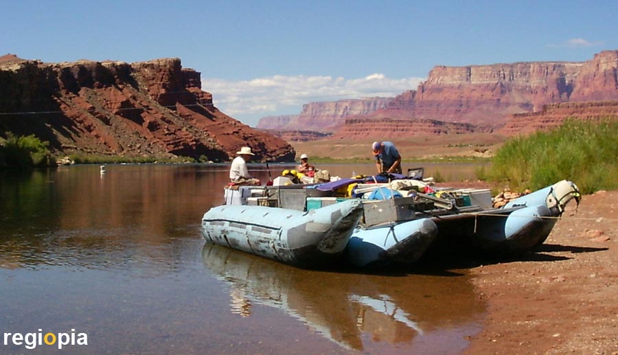
Colorado River
The Colorado River rises in the Rocky Mountains in the US state of Colorado and flows through Utah, Arizona, Nevada and California before flowing into the Gulf of California in Mexico. It got its name from the Spaniards who called it "Rio Colorado" (colored river) because of its red color. The Colorado created the famous Grand Canyon on its way into the sea. Those who want to see the Grand Canyon from below can go on a river rafting tour on the wild river. A trip on the Colorado River should be planned well, some tours last over a week. It's faster with a motorboat, with a rowboat you swim at the speed of the water. The company Arizona River Runners (see link) offers various tours and works together with the national park administration.
Monument Valley
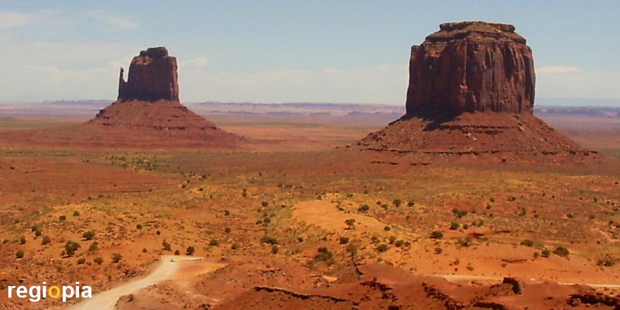
Monument Valley is located between Arizona and Utah, in the land of the Navajo Indians. The valley known from commercials and western films is about 230 km from the Grand Canyon. The red limestone was formed on the bottom of a lake that was transformed into a 2,000 m high plain around 70 million years ago when the earth's crust rose. Wind and weather carried away the soft rock layers until only the hard limestone rocks remained. The red rock towers are called "butte" by the Americans. In Monument Valley there is a visitor center from which a Scenic Drive starts, a circular route that you can drive with your own car. Here you can also book guided tours and stay overnight at The View Hotel.
Arches National Park
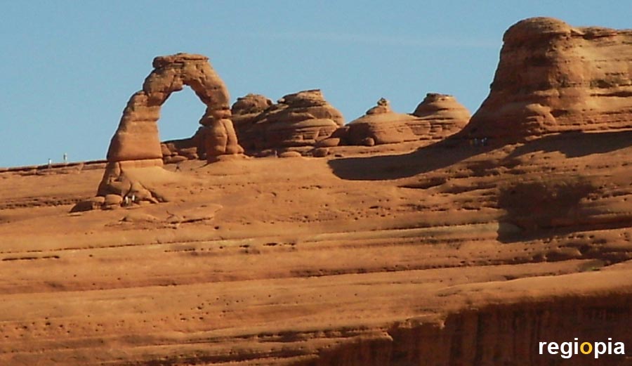
The town of Moab on the Colorado River in the US state of Utah is the gateway to Arches National Park. The national park impresses with a large number of large stone arches that were created through weathering. Different hard sandstone layers create the "Arches". First there is a gap, which over the years becomes a cave or gets holes. Over the millennia, this is what turns into the spectacular stone arches. When the arch collapses, huge stone pillars remain.
Death Valley
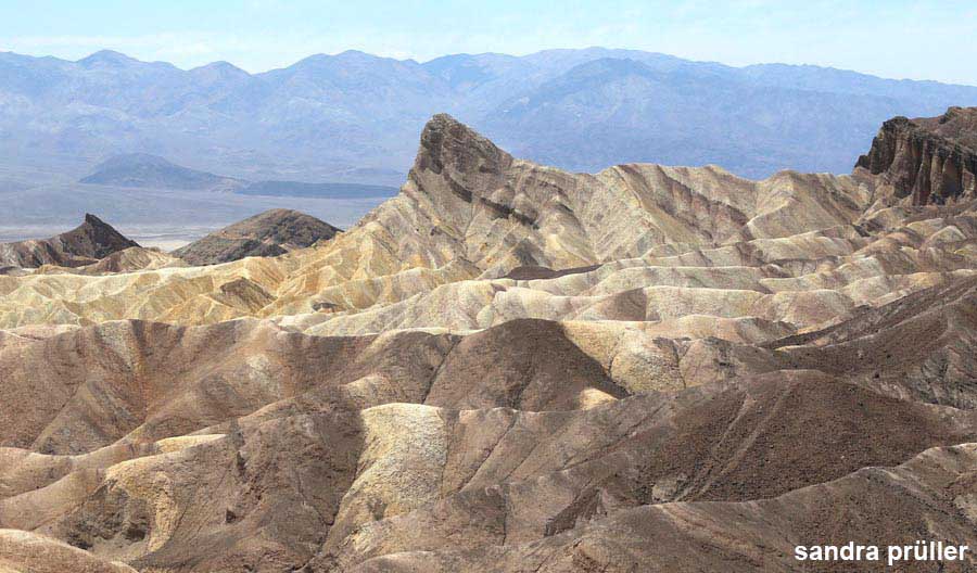
The "Death Valley" is one of the hottest places in the world. Temperatures of over 50 ° C are measured here in summer. The lowest point is about 86 m below sea level. The Wandering Stones are located at "Racetrack Playa". The phenomenon occurs when a thin layer of ice forms on the lake in winter and a strong wind sets the ice in motion. Then the stones are moved through the ice. When the ice melts, you can see the marks of the stones in the mud. The most beautiful photo opportunities can be found at "Zabriskie Point".
Historic Route 66
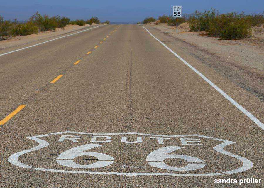
A section of the historic "Route 66" runs just south of Las Vegas. The "Historic Route 66" is still preserved between the towns of Seligman and Kingman in Arizona. The highway "Route 66" connected Chicago with Los Angeles but became superfluous due to the construction of the highways. A trip on the "66" is like a nostalgic trip through the American past. The legendary road is particularly popular with motorcyclists. The Route 66 became world famous through the movie "Easy Rider" and became one of America's tourist attractions.
Map of Nationalparks in Utah and Arizona
ads
National Parks
National parks of the USA
The most famous national parks of the USA are in the south-west, in the states of Utah, Arizona and California. From Las Vegas you can visit the national parks: Grand Canyon (North), Zion, Bryce Canyon, Capitol Reef, Arches, Canyonlands, Monument Valley and Grand Canyon (South). If you drive to California you can explore the "Death Valley" or visit the Mojave Desert. National parks in the north of California, like the Yosemite National Park, you'll find on San Francisco > Nature.
If you want to ride on a horse, in this unique landscape, just like a cowboy / girl, you can book a tour at Canyon Trail Rides:
ads
ads